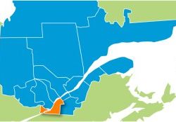
11 – Montérégie

General Information:
On the shore of the Gulf is the fertile Saint-Lawrence River Valley. To the east we also find the Richelieu River Valley. The terrain is moderately rugged to the Southwest, near the American border. The Northwest part of the region is bordered by the Saint-Lawrence to the south and the Ottawa River to the north. A large proportion of the trails are in the plain. There is plenty of woodland, mostly deciduous, and in particular, maple bush. The part located between Châteauguay and Boucherville immediately to the south of Montreal is very densely populated.
Practical Information:
- Regional network:
18 clubs (2,241 Km of trails) - Main trails:
5 at Cazaville (west) and at Sorel-Tracy (east)
33 at Saint-Télesphore (west) and at lac des Deux-Montagnes (north)
500 at Saint-Stanislas-de-Kostka (west) and Rougemont (east)
505 at Saint-Michel (west) and Saint-Hyacinthe (east)
510 at Sabrevois (west) and Wickham (east)
503 at the American border (south) and Beauharnois (north) - Accommodation accessible from the trail:
700 rooms - Snow conditions:
From mid-December until mid-March
Location:
Principal cities: Salaberry-de-Valleyfield – Châteauguay – Longueuil – Boucherville – Brossard – Saint-Jean-sur-Richelieu – Saint-Hyacinthe – Sorel-Tracy
Attractions:
- The chasm at Franklin (trail 5)
- Dinelle sugar shack at Saint-Rémi-de-Napierville (trail 5)
- Mont Saint-Grégoire (trail 510)
- The André l’Écuyer trail at Saint-Rémi-de-Napierville
- The Montérégie also offers 30 minutes access to all the attractions of Montreal.
From the region:
- Ontario to the west (trails 33, 312)
- New-York State to the south (trail 503)
- The Cantons-de-l'Est region to the east (trails 45, 505, 515)
- The Centre-du-Québec region to the Northeast (trails 5, 45)
- The Laurentides region to the Northwest (trails 33, 312)
- The Lanaudière region to the Northeast (trail 3)
Links:
 | 8940, boul. Leduc, bureau 10 Phone : 450 466-4666 ou 1 866 469-0069 |
Secure Hotels
There are no secure hotels affiliated with the FCMQ in this region for the moment.


